The Incident Information section is where the arresting officer enters details about the incident including: Agency File #, Date and Time of incident, Incident Type, Location, Cross Street, Mile Post #, City, Parish, Latitude, Longitude, Speed, Speed Limit, and selects whether the incident was Videotaped, if a Radar/Laser was used, and if a Child 12 years or younger was in the vehicle.
NOTE: Agency File #, Date and Time of Arrest, Location of Arrest, Date and Time of Incident, Incident Location, City and Parish are required fields.
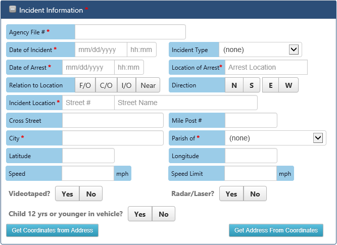
Incident Information section on Incident Information page
Enter details about the arrest in the Incident Information fields:
- Agency File #: Enter Case Management System/Record Management System #.
- Date of Incident: Enter the incident date or select date in the calendar control and enter the incident time in military time.
- Incident Type: Select the type of incident.
- Date of Arrest: Enter the arrest date or select date in the calendar control and enter the arrest time in military time.
- Location of Arrest: Enter the location at which the arrest occurred.
- Relation to Location: Select where the incident occurred (F/O, C/O, I/O, or Near) in relation to the location address.
- Direction: Select the direction (N, NE, E, SE, S, SW, W, NW) the arrestee was traveling when the incident occurred.
- Incident Location: Enter the street # and street name where the incident occurred.
- Cross Street: If applicable, enter the name of the cross street.
- City: Enter the city where the incident occurred.
- Mile Post Number: If applicable, enter the highway mile post number.
- Parish of Occurrence: Select the parish where the incident occurred.
- Latitude: If applicable, enter the latitude coordinate where the incident occurred (used for mapping incidents).
- Longitude: If applicable, enter the longitude coordinate where the incident occurred (used for mapping incidents).
- Speed: If the arrestee was speeding, enter the arrestee’s speed in miles per hour.
- Speed Limit: If the arrestee was speeding, enter the speed limit of the roadway.
- Videotaped: If the incident was videotaped, select Yes and enter the Video Tape VCN.
- Radar/Laser: If a radar/laser captured the arrestee’s speed, select Yes and enter Radar/Laser #.
- Child 12 yrs or younger in vehicle: Select Yes if a child 12 years or younger was in the vehicle.
The officer may also use the Get Coordinates from Address and Get Address from Coordinates buttons to prefill address or latitude/longitude coordinates. Clicking the Get Coordinates from Address button will trigger an attempt to geocode the input address into latitude/longitude coordinates. Clicking the Get Address from Coordinates button will trigger an attempt to reverse geocode the latitude/longitude coordinates into an address. The information returned from the geocoding services should be verified by the officer. The latitude/longitude coordinates are used to map incident locations.
To continue with the DWI Arrest draft, the officer moves to the Violation/Charges section. To expand the Violation/Charges section, click on the section header or the + symbol in the header bar.
